


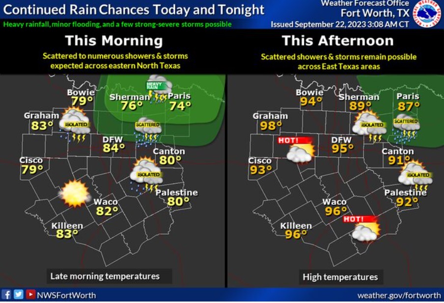
Scattered to numerous, showers and storms will develop across eastern North Texas this morning, then linger across the far eastern areas this afternoon. A few storms could be strong to severe, as well as contain locally heavy rainfall that may produce localized minor flooding.
Dallas- Fort Worth (WBAP/KLIF) – Dallas is in store for more storms today and into the weekend.
Much needed rain fell across the metroplex this week. Unseasonably warmer and humid weather are on tap to accompnay more today [Friday] Saturday and Sunday.
Rain coverage will be highest along our northern counties. The main concern here will be strong winds and hail. A complex of storms moved in late Thursday into Friday from Oklahoma. This complex could bring some strong storms, with strong winds as the main concern, with the main concern being northern and northeastern counties.
Weekend forecast:
Today
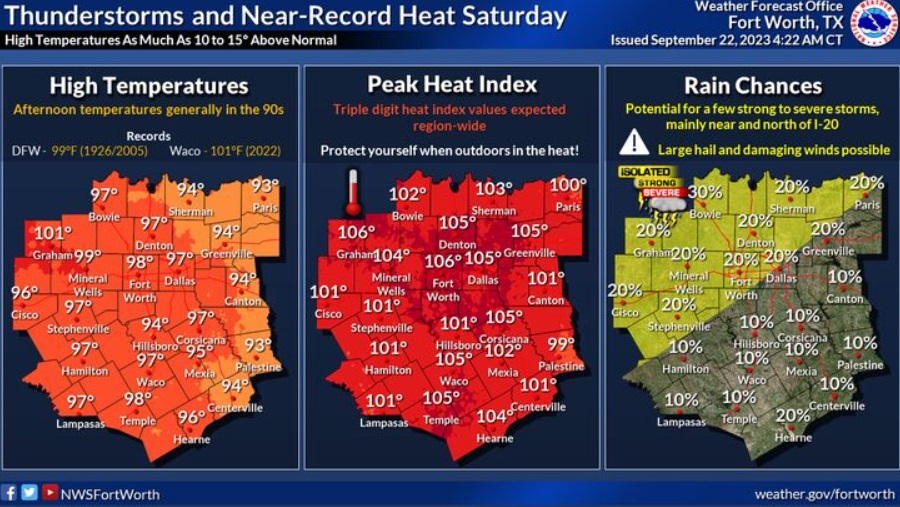
A 30 percent chance of showers and thunderstorms, mainly between 7am and 1pm. Mostly sunny, with a high near 95. Heat index values as high as 99. South wind 5 to 10 mph, with gusts as high as 20 mph.
Tonight
Mostly clear, with a low around 77. Southeast wind around 10 mph, with gusts as high as 20 mph.
Saturday
A 20 percent chance of showers and thunderstorms after 1pm. Mostly sunny, with a high near 97. Heat index values as high as 105. South wind 10 to 15 mph, with gusts as high as 20 mph.
Saturday Night
A 30 percent chance of showers and thunderstorms, mainly after 1am. Partly cloudy, with a low around 77. South wind around 15 mph, with gusts as high as 20 mph.
Sunday
A 50 percent chance of showers and thunderstorms. Partly sunny, with a high near 97. South wind 10 to 15 mph, with gusts as high as 20 mph.
Sunday Night
Showers and thunderstorms likely, mainly before 1am. Mostly cloudy, with a low around 71. South southeast wind 10 to 15 mph becoming east northeast in the evening. Winds could gust as high as 20 mph. Chance of precipitation is 70%.
(Copyright WBAP/KLIF 2023. All rights reserved)