


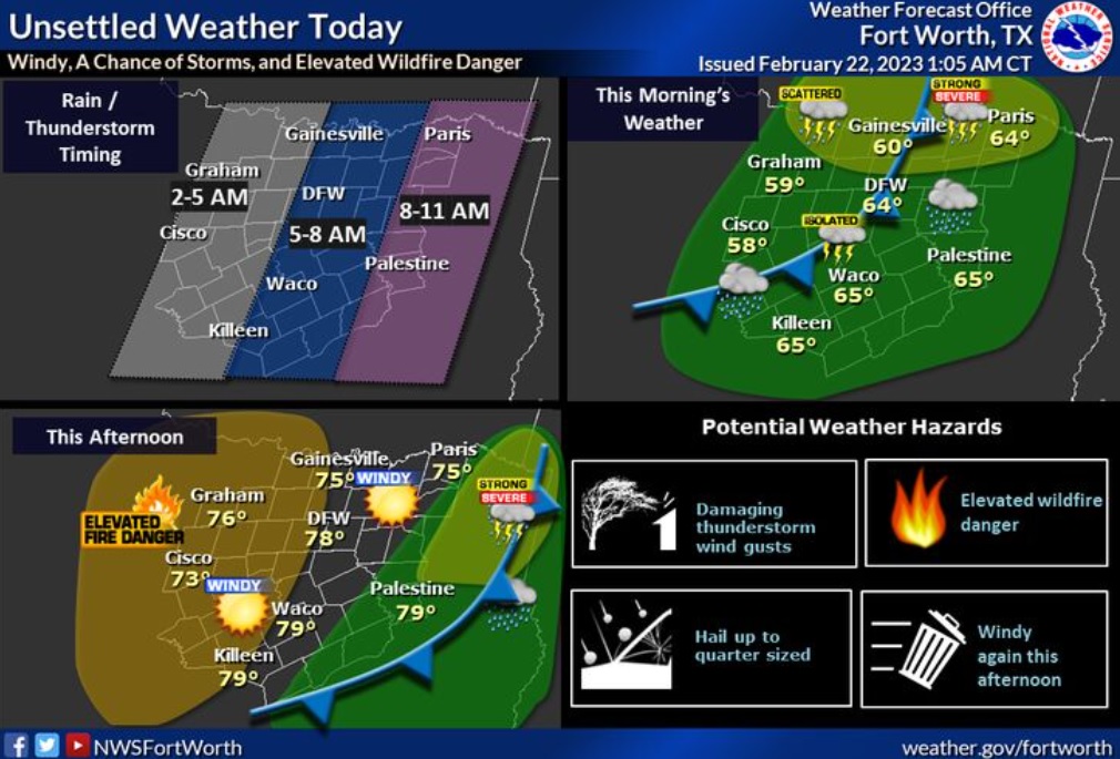
Unsettled weather is expected today as an upper level disturbance and a Pacific front bring a chance of showers and storms. The best storm chances will be across the northern rows of counties, which is also where the best chance of strong to severe storms will be. Windy conditions will return this afternoon behind the front, which will create elevated fire weather conditions west of I- 35.
Wednesday
Showers and possibly a thunderstorm before 9am, then a chance of showers between 9am and noon. High near 78. Breezy, with a south southwest wind 15 to 25 mph, with gusts as high as 30 mph. Chance of precipitation is 80%. New precipitation amounts of less than a tenth of an inch, except higher amounts possible in thunderstorms.
Wednesday Night
Clear, with a low around 55. South southwest wind 5 to 15 mph becoming west after midnight.
Thursday
Mostly sunny, with a high near 69. West northwest wind 5 to 10 mph becoming north northeast in the afternoon.
Thursday Night
Mostly cloudy, with a low around 49. North northeast wind around 10 mph.
Friday
A chance of showers, with thunderstorms also possible after 3pm. Cloudy, with a high near 59. Northeast wind around 10 mph. Chance of precipitation is 40%.
Friday Night
A 30 percent chance of showers and thunderstorms. Cloudy, with a low around 49. North northeast wind around 10 mph.
Saturday
A 20 percent chance of showers before noon. Cloudy, with a high near 64. Northeast wind 5 to 10 mph.
Saturday Night
Cloudy, with a low around 56. Northeast wind 5 to 10 mph becoming south southeast after midnight.
Sunday
A 30 percent chance of showers, mainly after noon. Cloudy, with a high near 77.